
Welcome to my guide to the best walks in Galloway Forest Park!
Often overlooked by visitors who head straight up to the Highlands and Islands, Galloway Forest Park is a real hidden gem. I love coming here, for the scenery, the solitude, and the sense of freedom I always feel here.
Located in Dumfries and Galloway and sometimes described as “the Highlands of the Lowlands”, the park offers spectacular landscapes and some of the most beautiful, untouched wilderness in the UK.
The park itself spans over 300 square miles (770 square kilometres), and includes the largest forest in the UK and a large section of the Galloway Hills. It’s one of my favourite places in southern Scotland.
You’ll find many well-marked hiking trails here, passing through a range of stunning scenery: rugged uplands, remote glens, ancient woodland, tranquil lochs, and sparkling mountain streams.

Best Galloway Forest Park Walks
Here’s a collection of my favourite walks in Galloway Forest Park.
There are routes for all ages and abilities, from easy family-friendly strolls to strenuous multi-day hikes in the mountains.
For further information on the various trails, local weather conditions, wildlife and more, visit one of the three visitor centres, located at Glen Trool, Clatteringshaws, and Kirroughtree.
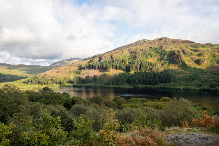
1. Glentrool & Loch Trool
Located in the heart of Galloway Forest Park – the largest forest park in the UK – the remote and beautiful valley of Glentrool is a forested wilderness containing several excellent hiking trails.
For a relatively short and easy hike, check out the Water of Trool Trail which takes in a scenic section of the Water of Trool (a mountain river), plus a great view of Spout Head waterfall.
This is a really enjoyable walk and one of the most accessible and well-marked Galloway Forest Park trails. It’s a great way to get a taste of the region’s stunning landscapes.
A slightly longer, moderate-intensity hike is the Loch Trool Loop. This is one of the most popular circular walks in Galloway Forest Park, and takes in a lap of the loch, passing through lush woodland.
The views out over the loch and up into the Merrick foothills are sublime. Keep an eye out for red squirrels, deer, mountain goats and ospreys.
Part of the route follows a section of the Southern Upland Way, a challenging long-distance, multi-day hike that runs from the west coast of Dumfries and Galloway to the east coast of Berwickshire.
History trivia: Robert the Bruce – the great warrior and King of Scotland – took refuge here in 1306-07 during the First War of Scottish Independence.
A large engraved stone (“Bruce’s Stone”) stands overlooking a beautiful view of the valley and commemorates Bruce’s victory over the English at the Battle of Glentrool.
2. Climb The Merrick
If you’re looking for a more strenuous day hike, consider tackling the Merrick.
As well as being the highest peak in the (fantastically named) Range of the Awful Hand, the Merrick is also the highest mountain in both the Southern Uplands and southern Scotland.
It’s not actually that tall, standing at 843 m (2,766 ft). However, the trail is rocky and steep in places, so a decent level of fitness is advised. The total length of the trail to the summit and back is about 9 miles (14 km).
In my view, this is definitely one of the best walks in Galloway Forest Park. It’s possible to complete the hike in around 5 hours.
However, you’ll probably want to take longer and be able to stop, enjoy the stunning scenery and not be rushed.

From the car park to the north of Loch Trool (near Bruce’s Stone), the path climbs steeply out of Glentrool and into the mountains. Before you leave the tree line, look out for the Kilsharg bothy.
Bothies – basic huts providing shelter in the wilderness – are found all over the remote, mountainous areas of Scotland.
If you’re interested in giving bothying a go, I can wholeheartedly recommend the excellent Scottish Bothy Bible. I actually met the author while staying in a bothy in Knoydart – he’s extremely knowledgeable and his book is great!
Once you clear the forest zone, there’s a marker on the path announcing the start of the montane zone.
From here, the views start to open up and become spectacular: vast stretches of wild and untouched natural beauty, ancient forests, lochs and rugged peaks.
On a clear day, you can see all the way across to Northern Ireland and the Isle of Man.

On a cloudy day, you can’t.
As you reach the first (false) summit (called Kilsharg), you’ll finally see your ultimate destination, connected by a ridge known as the Neive of the Spit.
The summit of the Merrick itself is marked by a large cairn and a white triangulation tower.
Most people choose to retrace their steps from the summit back down into Glentrool to the car park.
There is an alternative route, via Loch Valley, which can turn this hike into a circular route.
However, be warned that this alternative route is poorly marked (it’s not marked at all in places – bring a good map) and can be very boggy.

3. Cornish Hill
A shorter and less strenuous alternative to the Merrick, the Cornish Hill trail is another of Galloway Forest Park’s best walks.
The route follows a well-marked path and offers excellent views out over the northern stretch of Galloway Forest Park and the Ayrshire countryside.

The trail starts from the car park at Stinchar Bridge, about 7 miles south of the village of Straiton.
After hiking for about a mile through a pretty stretch of woodland, the track starts to climb. Once you clear the trees, keep following the track all the way up to the top of the hill.
The summit of Cornish Hill offers good views of several other peaks in the area. On a clear day, you can see Shalloch-on-Minnoch, the Merrick, and the Isle of Arran in the far distance.
Here’s a collection of the best hiking captions for Instagram.
4. Otter Pool & The Raiders’ Road
The Raiders’ Road is a 10-mile (16 km) unpaved forest drive which runs between Clatteringshaws Loch and Loch Ken.
It’s open to vehicles between May and the end of October, although hikers can use the route year-round.
As well as the main track, there are many other hiking trails through the forest. These are mostly well-marked and fairly flat.
Red kites, buzzards and ospreys are common sights among the pines and the wildflowers.
About halfway along the Raiders’ Road is a tranquil spot called the Otter Pool. Here, a little river called the Black Water of Dee forms a series of pools and mini waterfalls.
It’s very picturesque and a wonderful place for a picnic and/or a dip, surrounded by trees and nature.

If you have the right gear – and the inclination – this is also a fantastic place to wild camp.
As an added bonus, at dawn and dusk, otters sometimes come out to play here. If you’re quiet, still (and lucky), you might just spot one.
5. Loch Doon & Loch Riecawr
Loch Doon is one of the largest freshwater lakes in southern Scotland and lies in the northern part of Galloway Forest Park. In this area, you’ll find some of the best walks in Ayrshire.
There are several hiking trails along the shores of Loch Doon and in the surrounding woodland. The southern end of the lake, past the ruined Loch Doon Castle, is particularly picturesque.

One excellent hike runs from the car park at Craigmalloch along the woodland trails to the tranquil and remote Loch Riecawr, passing through the dense Carrick Forest.
The route is a well-maintained dirt road and runs along part of the Carrick Forest Drive.
It’s a fairly gentle stroll but offers some really wonderful views. To extend this hike, you can continue all the way to Loch Bradan.
This is a very quiet, peaceful area and you probably won’t see many other people up here. It’s a perfect place to tune out and unwind in nature.
Galloway Forest Park Walking Maps
Before setting out to explore any of these Galloway Forest Park walks, I’d strongly recommend picking up an Ordnance Survey map (OS map) of the area.
These are some of the most detailed topographical maps in the world, and are incredibly helpful when planning walks (and places to camp), as well as when navigating along the way.
These are the three main OS maps covering Galloway Forest Park.
The 1:50,000 scale map covers the whole park, whereas the (more detailed) 1:25,000 is split into two, each covering the North and South areas respectively.
Suggested Packing List
Your full packing list for walking in Galloway Forest Park will depend, largely, on exactly where you will be walking, and at what time of year.
However, as a helpful starter, I’d suggest that you bring the following as a minimum when doing any of these Galloway Forest Park hikes:
- comfortable backpack with a waterproof rain cover (I really rate Osprey packs, though the size needed will depend on the length of your walk)
- a few drybags
- lightweight clothes that are quick-drying (i.e. not denim or cotton)
- waterproof jacket & trousers
- comfortable hiking boots & decent socks
- enough food to last the walk (plus a bit extra, just in case)
- large water bottle (or two, depending on where you’re going)
- water purification tablets or a filtration system (I really rate the Grayl Geopress)
- headtorch (just in case…)
- first aid kit (including blister plasters)
- bags for carrying out rubbish
- Ordnance Survey map(s) of the area(s) you will be in (get the old-school paper version – it won’t run out of battery)
- compass, if doing a significant amount of navigation (especially in the mountains and moorlands)
Accommodation In Galloway Forest Park
There is a good selection of places to stay in Galloway Forest Park. You’ll find something to suit all budgets, from simple campsites to luxurious holiday cottages.
There’s even a small manor house that you could rent for a special occasion!
Click here to compare the latest prices.
Want to plan a trip but not sure where to begin? Why not hire me as your personal travel planner…
Other Activities In Galloway Forest Park
As well as hiking and hillwalking, Galloway Forest Park is home to some excellent mountain biking trails (including two of the famous “7stanes” mountain bike trail centres).
It’s also a popular place for rock climbing, and ice climbing in the wintertime.
There are loads of great spots for fishing within the park. Most (though not all) of these require you to obtain a permit in advance from Forestry and Land Scotland.
Ask in one of the visitor centres for more information.
Galloway Forest Park is also a fantastic place for spotting local wildlife. Keep an eye out for otters, mountain goats, red deer, red squirrels, kites, nightjars, black grouse, ospreys, and golden eagles.
The park’s Red Deer Range has a viewing area and hide, which you can visit for free and is a great way to get close to Britain’s largest native land mammal.
If you want to see more of Scotland, I’d recommend this excellent road trip itinerary on whatdoyousea.com.
Or, check out some of my other hiking-related posts, including:
Other Posts About Visiting Scotland
- 29 Hidden Gems in Scotland
- 10 Best Luxury Lodges in Scotland
- Wild Camping In Scotland: The Ultimate Guide
- Camping In Galloway Forest Park: Beautiful And Untouched
- Best Wild Camping Tents – Ultimate Buying Guide & Review
- 45+ UK Hidden Gems: Discover Britain’s Best-Kept Secrets
- 19 Best Beaches on the West Coast of Scotland
Like This Post? Pin it!


One Comment
This is a great blog post! I love reading about all the different things to do in Galloway Forest Park. I’m definitely going to have to check out some of the trails!